![Lowrance HDS 7m — управление аудио на экране: функции и настройки [99/127]](/img/pdf.png)
Lowrance HDS 7m — управление аудио на экране: функции и настройки [99/127]
![Lowrance HDS 7m [99/127] Selecting the audio source](/views2/1298079/page99/bg63.png)
| 97
Audio | Lowrance HDS Gen2 Touch
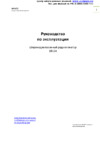
The audio media bar
When audio is enabled, the media bar will appear at the bottom of
the screen on all pages. The media bar varies from one audio source
to another.
You can switch focus between pages and the media bar by tapping
on the selected panel. The menus differ from one audio source to
another as shown in the following sections.
Operating the audio source
Selecting the audio source
You switch between available audio sources from the Source menu.
¼ Note: The Mic source selects a high voltage level input allowing you
to broadcast loud hailer messages over the audio system.
Adjusting the volume
The volume is adjusted by pressing the dedicated zoom
keys or by tapping Volume on the menu and then
dragging your finger on the slide bar.
Muting
You can toggle muting on/off by tapping Mute on the menu.
Volume
level
iPod media bar
Repeat
Audio Source
Artist
Track
Shue
Audio Source
Station
RDS Display
Signal strength
Volume level
FM radio media bar
Содержание
- Hds gen2 touch p.1
- Lowrance com p.1
- Chartplotter operator manual p.1
- Lowrance and navico are registered trademarks of navico fishing hot spots is a registered trademark of fishing hot spots inc copyright 2014 fishing hot spots navionics is a registered trademark of navionics inc nmea 2000 is a registered trademark of the national marine electronics association additional mapping data copyright 2014 nsi inc copyright 2014 by richardson s maptech p.2
- Copyright 2014 navico all rights reserved p.2
- Warning warning it is your sole responsibility to install and use this instrument in a manner that will not cause accidents personal injury or property damage always observe safe boating practices p.2
- Warranty p.3
- Preface p.3
- Declarations and conformance p.3
- Copyright p.3
- About this manual p.4
- Touchscreen calibration p.4
- The software p.4
- Waypoints routes trails p.5
- Introduction p.5
- Contents p.5
- Basic operation p.5
- The instruments panels p.6
- The alarm system p.6
- Structuremap p.6
- Navigating p.6
- Utilities p.6
- Using video 9 and 12 units only p.6
- Using the simulator p.7
- Using the radar optional p.7
- Using ais p.7
- System settings p.7
- Point 1 antenna p.7
- Networking p.7
- Siriusxm weather north america only p.8
- Maintenance p.8
- Gofree wireless p.8
- Introduction p.9
- Hds gen2 touchscreen and keys p.9
- The hds gen2 touch home screen p.10
- First time startup p.11
- Basic operation p.11
- Using the touchscreen p.11
- The power key p.11
- Page menus p.12
- Page menus p.13
- Hidden system menu p.13
- Back button p.13
- Settings dialog p.14
- Dialog boxes p.14
- Using the cursor p.15
- Positioning a man overboard waypoint p.15
- Panning p.15
- Cursor assist mode p.15
- Screen capture p.16
- Delete a mob waypoint p.16
- Cancel navigation p.16
- Page overview p.17
- Selecting pages quick splits p.17
- Selecting active panel p.18
- Saving favorites p.18
- Customizing pages p.18
- Adjusting splits p.18
- Selecting active panel p.19
- Saving favorites p.19
- Editing favorites p.19
- Customizing pages p.19
- Adjusting splits p.19
- You can toggle the overlay data type between an analog and digital display select data size and change previously configured data from the edit overlay configuration menu p.20
- Deleting favorites p.20
- Data overlay p.20
- Customizing overlay data p.20
- Allows you to overlay information on the active page you can turn on off viewing of overlay data and edit add overlay data by accessing the hidden system menu from any page screen p.20
- The chart page p.21
- Vessel symbol p.21
- Zooming p.22
- Using the cursor on the chart page p.22
- Panning the chart p.22
- Goto cursor p.22
- Chart scale p.22
- Saving waypoints p.23
- Measuring distance p.23
- Creating routes p.23
- Chart menu p.23
- Orientation p.24
- Chart options p.24
- Look ahead p.25
- D chart view options p.25
- Imagery p.26
- Chart detail p.26
- Displaying information about chart and chart objects p.27
- Categories p.27
- Selecting chart data p.28
- Chart overlay p.28
- Range rings p.29
- Heading and course extension p.29
- D boat selection p.29
- Chart settings p.29
- Boat settings p.29
- Waypoints routes and trails p.30
- Pop up information p.30
- Orientation p.30
- Navionics chart options p.30
- Look ahead p.30
- Grid lines p.30
- Community edits p.31
- Optional settings for navionics charts p.33
- Navionics settings p.33
- Jeppesen dynamic tides and currents p.34
- Waypoints routes trails p.35
- Waypoints p.35
- The waypoints route and trails screens p.35
- Positioning waypoints p.36
- Edit waypoints p.36
- Routes p.37
- Creating new route from chart page p.37
- Edit a route p.38
- Creating routes using existing waypoints p.38
- Autorouting and easy routing non americas units only p.39
- ¼ ¼ note a warning dialog will appear if any user entered route points are in unsafe areas to relocate an unsafe route point move the point and repeat steps 3 and 4 from autoroute easy route setup p.40
- The route will appear in preview mode allowing you to move any desired route points p.40
- Route points will turn red when selected p.40
- ¼ ¼ note in preview mode autoroutes and easy routes use colors to highlight safe and unsafe areas in a route autoroutes use red unsafe and green safe easyroutes use red unsafe yellow dangerous and green safe p.40
- Trails p.41
- Trail settings p.41
- Creating a new trail p.41
- Navigating on the chart p.42
- Navigating p.42
- Goto cursor p.42
- Selecting start point p.43
- Navigation settings panel p.43
- Cancel navigation p.43
- Xte limit cross track error p.44
- Xte alarm cross track error p.44
- Trails p.44
- Phantom loran p.44
- Logging type p.44
- Arrival radius p.44
- Steer page p.45
- Turning on structuremap overlay p.46
- Structuremap p.46
- Selecting structure source p.46
- Saved mode p.47
- Live mode p.47
- Transparency p.48
- Structure options p.48
- Water column p.49
- Palette p.49
- Noise rejection p.49
- Logging structure data p.49
- Frequency p.49
- Converting files p.49
- Contrast p.49
- Accessing structuremap files on sd card p.50
- Using structuremaps with mapping cards p.50
- Converting files in high resolution p.50
- Show structuremap smf files p.51
- Sharing files p.51
- Scanning tips p.51
- Scanning fishing areas p.51
- The instruments panels p.52
- The dashboards p.52
- Customizing the instrument panel p.52
- Edit an instrument dashboard p.53
- Using video 9 and 12 units only p.54
- The video page p.54
- Setting up the video page p.54
- The alarms dialog p.55
- The alarm system p.55
- Multiple alarms p.56
- Type of messages p.56
- Single alarms p.56
- Acknowledging an alarm p.57
- Vessels p.58
- Utilities p.58
- Waypoints routes trails p.59
- Trip calculator p.59
- Trip 1 trip 2 p.59
- Sun moon p.59
- Alarms p.59
- Alarm settings p.59
- Alarm history p.59
- Active alarms p.59
- Viewing screenshots p.60
- Satellites p.60
- Copying files to sd card p.61
- Settings p.62
- Pdf reader p.62
- System settings p.63
- Changing system settings p.63
- Satellites p.64
- Restore defaults p.64
- Magnetic variation p.64
- Coordinate system p.64
- Advanced p.64
- Using the simulator p.65
- Simulator mode p.65
- Selecting simulator source files p.65
- Demo mode p.65
- Advanced simulator settings p.66
- Using the radar optional p.67
- Radar operation modes p.67
- Using the cursor on the radar page p.68
- Saving a waypoint p.68
- Goto cursor p.68
- Adjusting range p.68
- Range rings p.69
- Radar menu p.69
- Measuring range and bearing to a target p.69
- Adjust p.69
- Position p.70
- Symbology p.71
- Ebl vrm p.71
- Setting a guard zone around your vessel p.72
- Ebl vrm settings p.72
- Defining an ebl vrm marker p.72
- Alarm when p.73
- Adjust p.73
- Target expansion p.73
- Sensitivity p.73
- Radar settings menu p.73
- Defining a guard zone p.73
- Target trails p.74
- Stc curve p.74
- Radar orientation p.74
- Palette p.74
- Threshold p.75
- Range rings p.75
- Range markers p.75
- North indicator p.75
- Fast scan p.75
- Compass p.75
- Bearings p.75
- Cancelling target tracking p.76
- Tracking marpa targets p.76
- Marpa target symbols p.76
- Viewing target information p.77
- Marpa target settings p.77
- Defining dangerous vessels p.77
- Vessel alarm settings p.78
- Radar overlay p.78
- Sidelobe suppression broadband radar only p.79
- Radar status p.79
- Radar installation menu p.79
- Adjust range offset p.79
- Adjust bearing alignment p.79
- Adjust antenna height p.79
- Restore radar to factory default p.80
- Using ais p.81
- Target symbols p.81
- Viewing information about all ais targets p.82
- Viewing information about ais targets p.82
- Selecting single ais targets p.82
- Vessel alarms p.83
- The vessel settings panel p.83
- Your vessel s mmsi number p.84
- The vessels extension lines p.84
- Filtering the targets p.84
- Defining dangerous vessels p.84
- Point 1 configuration p.85
- Point 1 antenna p.85
- Instance p.86
- Disabling the heading sensor p.86
- Compass offset p.86
- Cog sog filter p.86
- Calibrate p.87
- Gnss configuration p.87
- Networking p.88
- Data sources p.88
- Auto configuration p.88
- Configuring data sources p.89
- Renaming a data source p.90
- Remove p.90
- Damping p.90
- Diagnostics p.91
- Device list p.91
- Calibrating devices p.91
- Output sentences p.92
- Output p.92
- Nmea 2000 p.92
- Nmea 0183 p.92
- Ethernet p.92
- Sirius status us only p.92
- Serial ports p.92
- Receive waypoint p.92
- Vessel setup p.93
- Fuel used p.94
- Find fuel p.94
- Setting up wifi 1 p.95
- Setting hds device name p.95
- Gofree wireless p.95
- Enable disable wireless control of hds p.96
- Downloading the gofree app p.96
- Connecting the wireless device to wifi 1 p.96
- Operating the hds with a wireless device p.97
- Sonichub p.98
- Fusion radio p.98
- Adjusting the volume p.99
- The audio media bar p.99
- Selecting the audio source p.99
- Operating the audio source p.99
- Muting p.99
- Audio controls p.100
- Using the am fm radio p.101
- The playback menu p.101
- Shuffle and repeat p.101
- Selecting am fm tuner region p.101
- Using siriusxm radio p.102
- The channels list p.102
- Saving a channel to the favorite list p.102
- Auxiliary sources p.102
- The favorites list p.103
- Locking channels p.103
- Audio controls p.104
- Vhf setup p.104
- Vhf operation p.104
- Fusion link p.104
- Dvd operation p.105
- Siriusxm p.107
- The weather display p.108
- Siriusxm weather north america only p.108
- Weather symbology p.109
- Showing detailed weather information p.109
- Precipitation p.109
- Wind symbols p.110
- Weather icons p.110
- Wave indication p.110
- Sea surface temperature sst p.110
- Adjusting the color shading p.110
- Weather alarms p.111
- Weather overlay transparency p.111
- Weather reports p.112
- Tropical statements p.112
- Marine zones p.112
- Animating siriusxm weather graphics p.113
- Simple maintenance procedures p.114
- Preventive maintenance p.114
- Maintenance p.114
- Troubleshooting p.115
- The latest software for this unit will be available for download from our web site www lowrance com p.115
- Software upgrades p.115
- Detailed instructions for how to install the software will follow the upgrade files p.115
- Backing up your system data p.115
- Exporting waypoints routes and trails p.116
- Purging deleted waypoints routes and trails p.117
- Navico databases license agreement p.124
- Databases limited warranty p.125
Похожие устройства
-
 Lowrance LSS-1Руководство пользователя
 -
 Lowrance X515C DFРуководство пользователя
 -
Lowrance X136 DFРуководство пользователя
-
Lowrance X126 DFРуководство пользователя
-
Lowrance X125Руководство пользователя
-
 Lowrance HDS 10mРуководство пользователя
 -
Lowrance HDS 8mРуководство пользователя
-
Lowrance HDS 7Руководство пользователя
-
Lowrance HDS 5xРуководство пользователя
-
 Lowrance Elite-5 DSIРуководство пользователя
 -
 Lowrance BR-24Руководство пользователя
 -
Lowrance HDS 5mРуководство пользователя
Изучите, как управлять аудио на экране с помощью медиа-бара. Узнайте о переключении источников, регулировке громкости и других функциях.